Here are some big picture observations for when I run one of these again.
Packing food in dropbags. It can be quite overwhelming to try to plan out dropbags for this distance. Both here and at Moab, I tried to write out how many calories I should pick up and carry with me at each aid station. A few aid stations into Bigfoot, I was reminded how great the aid stations are. If you can stomach real food and you (correctly) tell yourself it’s okay to sit down for a hefty amount of time, you are in great shape. Beginning with Johnston Ridge, I think I had two breakfast burritos (eggs, bacon, guac, no cheese) at each aid stations. Filled up my pack / bottles with Tailwind, and I only needed some extra gummies for each section.
Packing clothes in dropbags is another story.
Don’t fully trust the elevation profile. There are undulations that are not captured in profile just because of scaling. That’s probably not surprising. But the locations of some of the aid stations are off, relative to the terrain. For example, the Twin Sisters aid station is at the end of an out-and-back; you descend ~2.5 miles to the aid station, then turn around and climb back out. The Twin Sisters dot on the elevation profile should be moved to the left a bit. Minor. More often than not, I was pleasantly surprised when the aid station came early.
Also, the course section descriptions are very clear and helpful. Pay attention to them.
There are no easy sections. I might use the term, but it’s all unrelenting.
Without further adieu…
Start to Blue Lake: I settled into an easy pace early, catching up with east coast speedster Jordan Chang, whom I had met for the first time at registration. We stuck together, occasionally with one or two other guys, for much of this section. There’s a decent climb, a boulder field or two that slows you down, and a nice smooth descent through the PNW forest.
You’ll probably catch some 20/40/100Kers going out with you. There will also be some 20 milers coming back towards you. This makes it one of the more social sections. The aid station serves all 4 races, so it can be a bit crowded. Drop bag situation was a little chaotic so I spent some time finding mine. I might avoid having one here in the future.
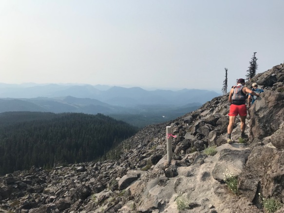
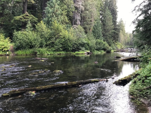
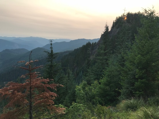
Blue Lake to Windy Ridge: I got the heads up to load up on water for this section (h/t Jared and Sara). It’s 18 miles with a lot of climbing, and most importantly, after a brief stint in the woods, you are totally exposed in the heat of the day. There are a few river/stream crossings here. I was able to hop over all of them, though it did require a bit of planning and a few leaps of faith onto rocks that I hoped were stable. Here’s a sense of the landscape:
40 milers and 100Kers are still with you here, so it’s still social. Although it’s often a barren landscape, the trails are quite runnable, and I was feeling good, so I made good time here. The rivers are a bit silty, but there is a stream / oasis a few miles before the aid station that was teeming with dehydrated runners topping off their bottles. I hopped right through. Overall, I was feeling great through this section, and I was thankful that I had carried a little extra water weight.
Windy Ridge to Johnston Ridge: You get a bit of a reprieve on the next two sections. The most noticeable features of this section are the times the trail leads you straight into a giant set of bushes. You essentially have to walk into a wall of leaves and branches and trust that there is a trail under your feet (there is). The areas are well-marked so they’re not bad. But it’s a bit crazy.
Steady climb up towards Johnston Ridge, and you can see the observatory in the distance. Might be some tourists around here. I was still feeling great around here. I sat down for the first time at Johnston, fixed my feet up a bit, and got some assistance from Adam Kat who was waiting for his runner.
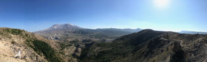
Johnston Ridge to Coldwater Lake. Easiest section of the course. Great views of Mt St Helens from up on the Ridge. Pretty decent descent, though not too steep, and very runnable trails.
The sun was less powerful at this point. Nothing too much to report from here. I cruised into Coldwater Lake and sat down for a bit, resting up for what would be a very tough section through the night. Started my trend of eating 2 breakfast burritos at each aid station, which I wouldn’t break until early Monday morning…
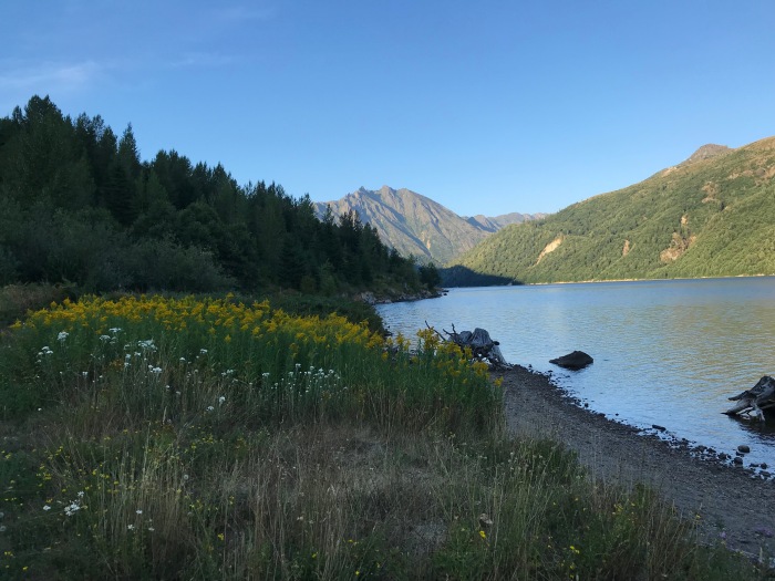
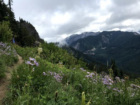
Coldwater Lake to Norway Pass. Coldwater Lake was gorgeous. The sun was slowly starting to go down as I started this section. You have a few flat / rolling miles along the length of the lake, wildflowers galore. Beautiful. Then begins one of the biggest climbs of the course.
Pre-race, I had the brilliant plan to push through the first night and make it to Lewis River (mile 112) before sleeping for the first time.
The climb after Coldwater Lake abruptly put a damper on these plans. As soon as the sun went down, I was overcome with some serious sleepiness. Caffeine, food, and water did not seem to help. I sat on the side of the trail, leaned over and tried to nap, but to no avail. Eventually, I told myself to push through this section and I would reward myself with a visit to the sleeping tent at Norway Pass. The carrot worked to some extent, and I was able to make it through this section without wasting too much time. Bit of a zombie walk/run.
Short out-and-back to Mt. Margaret–view is supposedly gorgeous–then a short stumble down the mountain into Norway, a delicious breakfast burrito, and off to the sleep tent. I set my alarm for about 1.5 hours after I lay down, and probably slept about 1 hour. Got up, a bit refreshed, but not totally invigorated, and I downed another breakfast burrito.
Norway Pass to Elk Pass: Another guy, Geno, was heading out at the same time; we had run a bit together in the first section, and we decided to team up for this section, which I was very happy to do, since it was night and I still wasn’t totally awake. He packed a lipper (!!) and we were on our way. A light drizzle began to fall as we left the aid station and would continue on and off for the rest of this section.
This section was one of the easier ones from an elevation perspective, But, we were also introduced to a new reality of the course: downed trees. It didn’t have the most blowdowns of any section, but it might have had some of the largest, and a few you had to make a difficult decision of going over or under.
As the first signs of dawn were coming, I found myself fatigued and decided to lie down on some mossy ground. I closed my eyes and took what was probably no more than a 5 minute power nap. I awoke as another runner was walking by, popped up surprisingly rejuvenated and was on my way, catching up to Geno soon thereafter. We stuck together through the rest of this section. I told him I was expecting my first child in a few months. We bonded a bit, in the way you can only do in the midst of one of these races.
Elk Pass to Rd 9327: I really enjoyed this section. It started out flattish / gently rising on a quasi-ridge line.
The rain was letting up when I started out but there was a lot of mist / fog. Very cool / ethereal / LOTR-feeling. I was getting my second wind as the day was brightening. There was a little bit of climbing, but I took the whole section pretty slow. And stopped for some pics.
Rd 9327 to Spencer Butte: There had been a tentative plan for Melisa and Danny to show up here to crew–I had stayed with them in Portland before the race, and I had to given them a very vague estimate of when I’d be here + they had friends arriving in town + there was no cell reception since 40 hours ago = I was setting myself up for them not showing up here.
But… as I approached the aid station, I saw four people locked in a high-stakes game of Kubb. Hurray! They made it! And my estimated arrival time was pretty damn accurate if I must say.
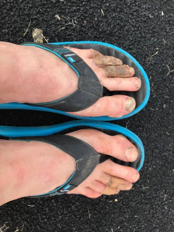
We did a little foot repair here. Danny taped up one pinky toe; Melisa did the other. Danny’s was better. I made them both aware of this. Danny was going to pace me for the next two sections, so we headed off to do a little of bonding.
This section was memorable for the company and the conversation but not as much for the scenery. Heavily wooded area. Nothing too memorable perhaps because I was focused on trail games. Ran into Melisa and friends picking berries here.
Spencer Butte to Lewis River: There’s a short section along a road to start where I had to force myself to run. Then begins a brutal brutal descent. I forget if I read about this somewhere and/or was just worried from the elevation profile, but this descent was in fact brutal. I got passed by two people here. Didn’t care too much.
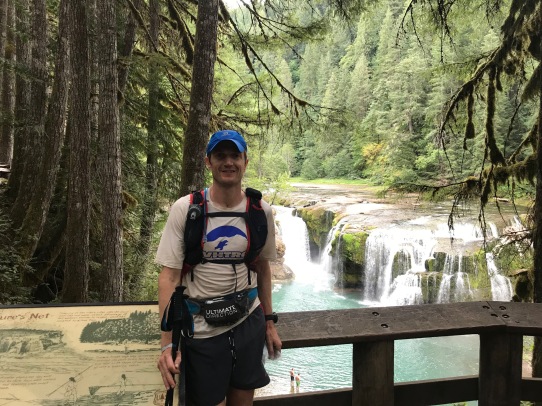
Eventually you pop our near a “Lewis River” campground, which is pretty well populated by campers and day hikers. It’s possible at this stage in the race, you will think that you are close to the next aid station (named “Lewis River”), which is a reasonable assumption. But you’re not. This section dragged on for me. Very beautiful but something about the crowded trails slowed it down for me.
Lewis River to Council Bluff: I spent a little time with the crew since they’d be heading back to Portland. In a race full of amazing volunteers, I had my first above-and-beyond experience with a volunteer (name forgotten!?!?!!), who–after informing me that the aid station didn’t yet have Tailwind–offered me some of his own stash. At first I tried to politely decline, but I knew this section would be tough, so I graciously accepted. Volunteers: beautiful people. I left the aid station with a smile, which… would not last long.
I had the misconception that it was a steady climb away from Lewis River / creek. The course description advises you to top off on water before you climb up out of the valley. So, the first time I crossed the river, and going off the elevation profile. I topped off. But, then, we ascended and descended and crossed the river, and ascended, descended, and crossed the river. And again. And again? I think? I was getting a little frustrated. And darkness was falling. But I eventually climbed out for the last time. And then darkness fell.
And then I started to lose it.
I could not keep my eyes open. I don’t even know how dangerous this section was, but it felt like if I took a wrong step, I would fall down a near cliff. And I did slip a few times, sometimes climbing over a log, sometimes just walking. A switch flipped in my head, and I was telling myself this was not worth it. I was ready to call it quits.
I found a flattish area next to the trail, laid down and took a 5 minute nap. I woke up and still felt abysmal so I put on my long pants, jacket and lay back down for another 5-10 minute nap. I woke up and felt even groggier. Finally, I took out my bivvy sack and climbed in. This nap seemed to do it. I got up, stuffed my sack away and trudged on.
The trail continued to gradually climb and switch back and forth. In the dark, I became convinced I was backtracking at one point, but I continued on.
Eventually I came to the aid station, which was run by a couple of 200-mile vets. One guy was a few PBRs deep, which was fun? I was pretty drained but he gave me some tough love and told me that last section was the hardest, which was reassuring.
Council Bluff to Chain of Lakes: This was a shorter, easier section with a bit of road. I’m pretty sure I fell asleep for a split second as I was running here. I was in full-on survival mode at this point, just trying to get to Chain of Lakes for a nap.
Chain of Lakes to Klickitat: I took another nap for about an hour at Chain of Lakes which was crucial. Got a good foot repair job, and I was ecstatic because the bottom of my feet were hurting big time. I thanked the volunteer that helped me profusely. He downplayed it a bit and also told me the tape job might not last too long because of three upcoming water crossings. womp, womp.
I headed out as the sun was coming up, still tired, but optimistic. Sure enough, it didn’t take long to come to the first crossing, short, but knee deep and a fast current. I think there was another short one you had to get wet in and then a long ~50+ foot crossing that was nice and cold.
I got a third/fourth wind on this section and there was a fair amount of flat terrain where I was able to run. It felt great!
Sustained climb to Elk Peak was tough but manageable. The final out-and-back section to get to the top was very steep, but the views were awesome from the top. My watch ran out of memory and deleted everything on the way down. Awww, man, no cool Strava posting I s’pose.

Klickitat to Twin Sisters. At Klickitat I got some not-amazing tape-work, then re-did it into fairly decent tape-work and changed socks and shoes. My feet were a mess and at this point, I just decided not to take off my shoes and socks again.
I feared this section the most. I knew I wanted to run this during the day because I’d read about this being a hard section to follow the markings. Ultimately, this section was very hard, but I think just because of my (good) state of mind and the fact that I got it all in daylight, it was manageable, and I just trudged on through without too much fanfare. There are two lakes that serve as potential water sources–I would not rely on these as legit sources.
Speaking of, I came upon another runner, Ryan, who was out of water–he had planned on filling up on the lakes, but finding them gross and stagnant, he declined. I gave him some water and tried to get him to take a spare half water bottle. I thought we were super close at this point but we had ~3 miles in reality. We stuck together for a few minutes; he said he had crew at Twin Sisters, so I soldiered on.
Twin Sisters to Owen’s Creek. I came into Twin Sisters and found Andy Pearson wrapped in blankets–apparently he’d had some fun with hypothermia earlier on. Also, one of the front runners had gotten off course, so I was in 4th place. I knew I was far back from the next person, but I was quite surprised to find I was this far up.
Twin Sisters had another memorable volunteer, Mark, who brought me burritos, soda, etc. and lied and told me I looked amazing. I pictured the next aid station as the finish line. Yes, there would be 13 miles more after that aid station. But if I got to Owen’s Creek, THEN I’d be on the home stretch. I was ready to do it.
I left Twin Sisters as dusk was falling and ‘flew’ up the climb. I wasn’t running but I was powerhiking with purpose, and I legitimately felt great. As the sun was going down I decided to pre-emptively drink a 5-hour energy, which I figured would take me through the night no problem.
Then night fell.
The out and back to Pompey Peak was tough and a little scary in pitch black. From there, it was essentially a long downhill to Owen’s Creek. No problem.
Yes problem. There were more downed trees than I could count. It was wet, slippery and, as I had on the two previous nights, I was losing it. Eventually the downed trees end, and I was introduced to the green tunnel.
This was an old fire road that was pretty straight, slightly down hill, covered in grass, and surrounded by dense growth on all sides. And it was night time, so any details that might have existed were not visible to me. Later on, I would be somewhat comforted when hearing other runners recount the monotonous horror of this section. But not for now.
I had heard several versions of a story of Bigfoot 2017 in which, late in the race, Van Phan, no stranger to ultras, was found in a trance on the trail. When asked if everything was okay, she replied, “I’m just stuck in a time warp and trying to get myself out.” Extracting herself from said time warp was a simple matter of throwing her poles down the trail, picking them up, throwing them, picking them, rinse repeat. I think in one version of the story, her ultimate escape was sealed by hurling the poles off a cliff on Pompey Peak. Obviously.
These stories to me sounded absurd. I had experienced mild hallucinations many a time and at Moab, I had gotten to a pretty dark space, but, time warp? I don’t think so. Wrong. The time warp is real.
I felt like I was running / walking on a treadmill with the same grassy path passing under my feet and the same dense forest passing on the sides. I would power hike for 10 minutes, look at my watch, and find that only one minute had passed. I would hike for 10 more minutes. One minute had passed. I was continuing to move, but I was not progressing.
I decided to play some music to confirm the passage of time. No headphones, but I frantically pulled out my phone, pulled up my music and played the first song I saw. LCD Soundsystem: All My Friends. Good song. Not a good song to listen to while trying to convince yourself time has not stopped. Two chords, no lyrics for the first minute. Honestly, pick anything else.
Anyways, I got through. Somehow. Eventually there were puddles and streams that I didn’t recognize, and I knew I was making progress. Then there was the bottle of tequila–I declined–and I knew I was close. And finally an aid station. I have never been so excited to see another human being.
Bachar was there. I relayed the last few hours of my life. I ate some food. I was ready to be done.
Owen’s Creek to Finish. It’s a half marathon to go. It’s a gravel road. Then a paved road. Then a barking dog who appears fierce, but he’s stuck on the other side of a fence, so what’s he going to do? Then it’s the dog reaching a gate, sliding under the gate and trotting after me, barking. It’s me walking backwards, swinging my poles to ward him off. Then he’s gone. Walking forwards now, very little running.
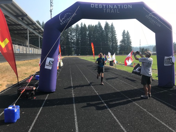
A car passes. Civilization. I’m listening to music on headphones to stay awake. The cracks in the tar are dancing figurines, but I know it’s not real. Then a right turn, and another. Then a bridge. One more right turn. Bachar drives by in our house-van. I’m close. It’s stadium lights in the distance. A lone cowbell. Hiking poles folded up.
A turn into the parking lot, entering the track, running as fast as I can. Not fast. Bachar’s filming. Me trying to look good for the camera. Failing. It’s a long slow turn on the far end of the track. The final straightaway. A blue inflatable arch. Volunteers, up from a nap, cheering me on, multiple cowbells. It’s me breathing it all in, on the verge of tears: happy, exhausted, proud, broken, grateful… finished.